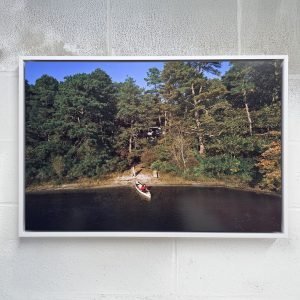
Winganhauppauge (Champlain’s Creek), 2026

$800.00

2026
Archival Inkjet Print
18 x 24 inches
Edition 1/10
Inventory 725

In stock

View in Room

SKU: 725 Categories: , Tag:

Description

Winganhauppauge (Champlain's Creek), currently on view in
Living Conduit – Indigenous History and Present Day, South Ocean Gallery at South Nassau Unitarian Universalist Congregation, Freeport, NY, October 3, 2026 – November 21, 2026

Winganhauppauge names a brook and neck of land in the Islip area of Long Island's South Shore. This view is near Champlin Creek at Union Boulevard and the northern end of Knapps Lake in East Islip. The older name carries a water-place meaning associated with flooded or overflowed ground. Its geography begins with the behavior of water and the land beside it.

Colonial records preserve spellings including Wingan Hauppauge, Winganhoppog, and Wingatthappagh. The name was associated with the brook or its headwaters before being applied more broadly. These variations record how Native language passed through other people's writing. The familiar translation Pleasant Springs is less secure than the connection to water and overflow. Keeping that distinction matters when recovering the meaning of a place.

The posted boundaries visible in this landscape belong to a later system of property and access. The Native name describes a relationship that crosses the neat division between land and water: a brook rises, floods, drains, and connects the ground around it. It also persists within records used to describe colonial holdings. Those documents can preserve Indigenous knowledge while making Native people appear only at the margins of a property transaction. Restoring the name's context gives priority to the landscape and the knowledge that made it meaningful before those records. Winganhauppauge belongs to the wider Native geography of Long Island, even when the most visible signs now identify a road, a lake, or private land. Its survival in language is a reason to learn the history of this particular place, rather than treating the South Shore as a landscape without Native relationships.

View in Room

Approximate scale using a 72 inch sofa.

Artwork: 24 x 18 inches
Reference couch: 72 x 34 inches, a typical two-person sofa

Exhibited & Provenance

Exhibition history and artist-direct provenance.

Living Conduit – Indigenous History and Present Day

South Ocean Gallery at South Nassau Unitarian Universalist Congregation, Freeport, NY, October 3, 2026 - November 21, 2026

Description

Winganhauppauge (Champlain's Creek), currently on view in
Living Conduit – Indigenous History and Present Day, South Ocean Gallery at South Nassau Unitarian Universalist Congregation, Freeport, NY, October 3, 2026 – November 21, 2026

Winganhauppauge names a brook and neck of land in the Islip area of Long Island's South Shore. This view is near Champlin Creek at Union Boulevard and the northern end of Knapps Lake in East Islip. The older name carries a water-place meaning associated with flooded or overflowed ground. Its geography begins with the behavior of water and the land beside it.

Colonial records preserve spellings including Wingan Hauppauge, Winganhoppog, and Wingatthappagh. The name was associated with the brook or its headwaters before being applied more broadly. These variations record how Native language passed through other people's writing. The familiar translation Pleasant Springs is less secure than the connection to water and overflow. Keeping that distinction matters when recovering the meaning of a place.

The posted boundaries visible in this landscape belong to a later system of property and access. The Native name describes a relationship that crosses the neat division between land and water: a brook rises, floods, drains, and connects the ground around it. It also persists within records used to describe colonial holdings. Those documents can preserve Indigenous knowledge while making Native people appear only at the margins of a property transaction. Restoring the name's context gives priority to the landscape and the knowledge that made it meaningful before those records. Winganhauppauge belongs to the wider Native geography of Long Island, even when the most visible signs now identify a road, a lake, or private land. Its survival in language is a reason to learn the history of this particular place, rather than treating the South Shore as a landscape without Native relationships.

Artwork Details
Title: Winganhauppauge (Champlain's Creek)
Year: 2026
Medium: Archival Inkjet Print
Size: 18 x 24 inches
Edition: 1/10

Shop

Browse print editions, framed works, mounted works, and books.

Back to all products

Cart